Hârn Geology
Geology of Hârn
March 25, 2013
What are the rocks that lie underneath all the kingdoms of Hârn? Why is there a salt mine at this particular location? Why is Lake Benáth so big? This article attempts to reconcile the information from the maps and canon writings of HârnWorld with real-world geology. Sometimes that's a difficult thing to do because Hârn is in fact too regular and too disparate at the same time.
With colourful maps and solid explanations, this is an invaluable aide to GMs and of interest to players. The Geology of Hârn is a worthy edition to anyone's collection.
by pokep
Note: ADD proper names and cross-internal links.
Note: ADD list of "special" details to add the various details for extras, ie. saltmarshes of Vashel, under Tamsen Forest.
Note: Text Highlight and Background Colour: Kandáy
Note: Green = I Have, Red = Don't Have, Orange = Old Scan, Blue = Misc, Black = ALL Base (Template)
Note: Colour Highlights: Yellow
Colour LINK Text: Possible Link NAME
Note: Hidden comments <!-- TEXT HERE WILL NOT BE DISPLAYED -->
Note: Anchor Points - Section linking WITHIN pages USE [[Help:Section#Section_linking|Section linking]] or To link to a section in the same page you can use [[#section name|displayed text]], and to link to a section in another page [[page name#section name|displayed text]].
Note: Section linking with arbitrary id USE <span id="anchor_name"></span>. Be sure to use a name that is not likely to be duplicated. One way to do this is to incorporate the titles of the higher-level sections, at least in abbreviated form, e.g., Ontario-Natural_features for the "Natural features" subsection of the "Ontario" section of an article about the provinces of Canada. ADD inside Table Caption/Heaer Text
Contents
- 1 Geology of Hârn
- 2 Part One: Geological Units
- 2.1 Alluvial Sedimentary Units
- 2.2 Complex Central Highlands
- 2.3 Non-Volcanic Central Highlands
- 2.4 Mixed Central Alluvial Units
- 2.5 Hefiosa Uplift
- 2.6 Misyn Karst
- 2.7 Peripheral Uplifts
- 2.8 Anadel Granites
- 2.9 Telumar Sediments
- 2.10 Káldôr and Anoth Depressions
- 2.11 Kathela Volcanic Plateau
- 2.12 Tuleme Basalts
- 2.13 Sorkin Core Region
- 2.14 Sorkin Volcanic Region
- 2.15 Sorkin Accretion Zone
- 2.16 Keron Island
- 2.17 Jahl Mountains
- 2.18 Exotic Volcanoes
- 3 Part Two: Geohistory
- 4 Part Three: Survey of Mines
- 5 A
- 6 Notes
Geology of Hârn
Preface
- Geology 01
Tracing the geological history of Hârn is a paradoxical task. There is little reason to believe that the creators of Hârn paid more than passing attention to geology as they mapped its contours and marked its features. There are hints buried here and there of some small plans, but no trace of an organic whole. For the most part, things are where they are on Hârn for the simple reason that N. Robin Crossby liked them there.
Of course, the creator was artist enough to give Hârn a patina of verisimilitude. For the person unfamiliar with geology, the maps look real enough. It takes a skeptic's eye to notice that the basic shapes and forms on Hârn aren't quite right. There aren't enough straight lines or any circles, the coastlines are too jagged, there is an odd lack of canyons and promontories, the rivers and mountains are too similar. Hârn just isn't as strange as reality.
So why even attempt a project like this? The only honest reason is that it is an interesting challenge. What is more natural than the intellectual desire to force order upon the unorderable? The absurdity of explaining the arbitrary gives the project a peculiar appeal, at least for this author.
But there is a practical benefit. The data here - if accepted by the GM - can be used to posit the results of prospecting, or to help describe gargun complexes, or provide a justification for an ancient edifice. Small details may have surprising ramifications in any game.
The basic premise of this project is simple - all the processes described here are well documented real world phenomena. Every feature has been explained as the result of processes that are known to occur in the real world. In addition, common features are explained by common processes, and rare processes are invoked only rarely. The result should seem reasonable and familiar to a modern geologist.
The primary clues used to solve this puzzle were the topography, landform descriptions in canon, and mines. The topography is the trickiest to evaluate. Both the Kelestia and the Columbia maps were used, and these maps have subtle differences. Both maps have their limitations. The Columbia maps provide very little information on contours and elevation. The Kelestia map has more topographical hints, but the process used to create the map obscures a lot of details. For example, mountain valleys are monotonously alike, which makes it impossible to know whether the valleys were shaped by glaciers. The Kelestia map does have more detail, and is also more refined, as new ideas can be seen in the map that clearly are missing from the older maps.
There are only a handful of passages in canon that address geology, notably in the Kingdom of Ázadmêre and Kiráz articles. The most interesting canon element is the karst landscape of Misyn. In fact it's the central riddle of Hârn - why is the very center of Hârn built from seafloor sediments?
Very rarely, canon descriptions were simply too far off-base to consider as true. For these, the canon descriptions were taken as being the common interpretation of Hârnic scholars, rather than the literal truth. Only the most egregious errors were treated this way, and they are clearly described as such in the text.
The mines are perhaps the most important element of all. They are widespread, and in places seem scattered at random. Ores that are rarely found together in the real world are juxtaposed with abandon on Hârn. Explaining the mineral lodes presents incredible challenges, and where we occasionally demand a leap of faith, it is inevitably to explain an oddly placed mine.
Absolutely no attempt was made to consider any fanon literature.
One process that was invoked but rarely was meteor impacts. As cliche as these have become in fantasy worlds, there is evidence for exactly one of them here, and it was minor. Lake Benáth is often discussed as a candidate, but the central valley is far from circular. It looks nothing like a real-world impact. A more plausible candidate is the Denia Marshes, which are smaller and more roughly circular. However, it is still not nearly as circular as we should expect and the rim not well defined. The explanation offered here has three advantages. It better matches the topography of the Denia Marshes, it explains the unique broad valley extending to the southeast of the marshes, and it provides for more interesting gaming, as the Denia Marshes now have a unique geological composition analogous to Yellowstone National Park.
Inevitably there will be disagreement and alternative explanations for almost every statement made here. The same is true in real world geology, where almost nothing can be stated without controversy. The only way to adjudicate such arguments is through careful field research, for which, unfortunately, grant money is hard to come by.
Part One: Geological Units
- Geology 02
- Geology 03
- Geology 04
- Geology 05
- Geology 06
As with any land mass, Hârn can be divided into a number of geological units. Each unit arose from a different sequence of processes, often from different base materials, and are marked by distinctive minerals and geological formations. The classification detailed here is a relatively coarse analysis. More detailed study might allow finer distinctions, and in turn, allow more units to be identified. Thus the contents of each unit should not be considered completely homogeneous, nor should the borders between them be interpreted as hard and absolute.
Alluvial Sedimentary Units
The largest portion of Hârn consists mostly of sedimentary rocks formed from material eroded from the several mountain zones. While a great amount of variation occurs, in general the sedimentary rock tends to be more finely grained and contain more calcite the farther from the central sources. Areas closer to the center of Hârn have sandier, more quartz-rich stone. Gravel is prevalent in the flood plains of ancient rivers, so gritstones and conglomerates mark the path of the ancient Thârd, Kald, and northwestern rivers.
These units contain few exploitable minerals. A few placer deposits exist where heavy minerals have eroded from mountain lodes, but these are usually poor quality. They are important mostly as a pointer to better deposits in the higher units. The main exception is the iron deposits along the floodplain of the ancient Thârd, which include the remarkable Hikun Mines.
 |
Note: ADD a floating table for legend under the Pic for showing all the colours, add a link to each colour heading.
Complex Central Highlands
The central mountains have a complex origin, and were formed through several different processes. They began as underwater strata formed when Hârn was a shallow sea. Thick layers of limestone, chalk, and dolomite were deposited over a sea bottom consisting of ancient rock. These layers were thrust up to form the early central highlands, and then largely eroded away. The unit then went through a period of volcanic activity. Magma reached the surface through numerous fissures, rebuilding the mountains. In some places magma failed to reach the surface and cooled slowly underneath, forming granite masses. The volcanic activity eventually petered out, and the region is now marked by erosion – especially glacial action.
The complex processes that formed these units also created a variety of mineral sources. During the volcanic period, hot water percolating through the porous stone concentrated minerals in specific locations. This process created the spectacular Kiráz deposits – certainly the richest on Hârn. Minerals were also concentrated through the slow differential cooling of magmas, and many exploitable lodes are associated with the granite intrusions. Deep in the roots of the mountains, exploitable banded iron deposits are found in the ancient undersea sediments that underlay the entire island. Finally, erosion has created placer deposits in some valleys within the unit.
The unit is composed of innumerable varieties of stone. Most distinctive are the various marbles formed where limestone and other carbonates came in close contact with hot magmas. The region is also famous for its granites. Basalt and limestone are common, but countless varieties of rocks and minerals are scattered through the region.
Non-Volcanic Central Highlands
This unit consists of those portions of the central highlands that did not experience significant volcanic activity. They consist almost entirely of carbonaceous sediments over ancient sedimentary rock, and are highly faulted and eroded. More recent sedimentary formations are common in the ancient valleys.
Mixed Central Alluvial Units
The origin of these units started with the same uplift of undersea sediments that formed the Central Highlands. But these areas were at a lower elevation, and thus faced less erosion and were themselves covered with alluvial sediments. Much of these areas were underwater, at least for some of their history, and in that time they were further covered with silt and clay sediments.
Slicing through these units would reveal a comparatively well preserved set of layers. Deep below are the primordial sediments that underlay all of Hârn. Above them, and occasionally reaching the surface, are the carbonaceous rocks that formed in the shallow Hârnic Sea. Where these sediments are at the surface caves and sinkholes are common. But mostly these areas are covered by a moderate layer of more recent sediments – mostly siltstones and claystones, but coarser stone is not uncommon.
These units offer a few exploitable resources, but are generally less productive than nearby units that have been subjected to a greater variety and intensity of geological processes. Banded iron formations in the deepest layers are rarely exposed, and water action occasionally concentrates minerals in the porous carbonaceous layer, but such deposits are limited in value.
Hefiosa Uplift
This unit was created by a relatively recent secondary uplift within a section of central Hârn. It consists mostly of granites, with an eroded upper layer of carbonaceous rock and some alluvial sediments. Iron deposits in the region are limited to the alluvial sediments – they are bog iron washed down from the prehistoric Benáth Basin. Tin and mica are the direct result of the granitic activity, while salt and gypsum are mined from remnants of an ancient salt flat.
The region is also notable for the scablands created by ice age floods. Steep-sided dry canyons mark the area. The bottom of these canyons are lined with stony and gravelly debris and sandbars – the size of the debris indicates the speed of the floodwaters that deposited them. Apparently there were several floods – most through the Thârd Canyon and the gap between the Pech and Imris Rivers.
Misyn Karst
This units marks where the carbonaceous sediments of the central uplift are thickest and best preserved. Early in the uplift period this unit collapsed into a deep graben valley. With its lower relative elevation the limestone was not subject to the severe erosion that removed much of the similar sediments from the surrounding mountains. While some sediments have covered parts of the region, the thick limestone is fully exposed over a wide part of the region, and only thinly covered anywhere.
This is a karst landscape. Since limestone is relatively soluble, water action readily dissolves caves and sinkholes within its mass. These caves are often spectacular, with abundant stalactites, stalagmites, and water features. Some minerals are concentrated by the water action, although few are commercially important.
Peripheral Uplifts
Among the more recent events in the geologic history of Hârn is the uplifting in peripheral regions that brought shallow sea floor sediments above sea level. Perforating these soft sediments are granite masses, the margins of which often contain valuable minerals. In some areas, such as Mèlderýn Isle, there is little to no granite, and the bedrock is entirely sedimentary. The softer materials tends to be easily eroded, forming rounded hills with light, porous soils. Thus much of these areas are rolling heathland
Two main kinds of sediments predominate in these units. Most common are chalks, but sandstone are found in the areas that were closer to the prehistoric shores – that is, the portions that are now inland. None of these sediments host much in the way of exploitable minerals. In a few places bog iron deposits have formed in prehistoric swamps, providing some ores of modest value.
Anadel Granites
It may be that uplifts in southeastern Hârn are related to the large granitic intrusions that form the spine of the Anadel Highlands. Over most of the region the granite is covered by the same carbonaceous sediments that dominate the surrounding unit, but where the granite is near enough to the surface to be mined some of the most productive tin and copper orebodies on Hârn are found. Granite is formed by magmatic material that cools while still under the surface, and if a large mass cools slowly, different chemicals precipitate from the magma solution at different levels of concentration. The precipitating minerals are thus concentrated in zones which can be profitably exploited. The best example is are the mines of the Kenmusi Downs, Birenshire, which tap into highly mineralized granites from this unit.
The distinction between the Anadel Granites and the neighboring Uplift Unit described previously is one of proportion rather than type. The two units are very similar, but the Anadel Region has a greater proportion of granite mass to sedimentary material.
Telumar Sediments
This unit is similar to the Alluvial Sedimentary Units that dominate Hârn, but were subjected to uplift in the relatively recent epoch. Like the larger units, it consists mostly of fine-grain sedimentary rock, fringed by sandstone in former coastal areas. Underneath are carbonaceous sediments. The region is pocked by granitic intrusions, perhaps related to the uplifting process. Where these intrusions are exposed are some of the most productive orebodies on the island.
The heat from the intrusions also transformed some of the sedimentary rocks. In a few places the deeper carbonaceous material was transformed to talc and soapstone. Elsewhere, terrestrial sediments were transformed to slate. But most of the mining activity involves porphyric deposits created directly within the granite.
Káldôr and Anoth Depressions
The broad swath of lowlands that lay between the mountain ranges were formed by the relative movement of the three main blocks. This motion has stretched the crust between the blocks, creating the lowlands in between much like pulling taffy thins it out. Where the stretching was the greatest – southern Káldôr and the Anoth Delta, the land is lowest. Northern Káldôr, in contrast, saw much less deformation and remains generally higher.
Geologically, the region consists mostly of alluvial sediments eroded from the mountain blocks. The sedimentary layers also include a substantial quantity of volcanic ash, blown over the area from the central volcanoes.
The region also features substantial banded iron formations. These deposits were created on the ancient sea bed by the precipitation of iron from the water, a process that is believed to be due to fluctuations in the oxygen content. They were covered by carbonaceous rocks when Hârn was still under water, then lifted into place early in Hârn's history as an island. In parts of Káldôr where the stretching and erosion has exposed this ancient sea floor, these hard, red-striped rocks are an important source of iron ore.
The region is relatively mineral-poor, but Káldôr hosts one of Hârn's more unusual ore-bearing formations. Early in Hârn's prehistory, much of Káldôr was apparently a large lagoon. Salt deposits accumulated in the slowly shrinking bay, which were buried by terrestrial sediments as the Hârnic mountains grew. The stretching of the region brought those salt deposit close enough to the surface to be mined in a few places in central Káldôr.
A few volcanoes exist in the region, and some mineral deposits are associated with them. The most important by far is Mount Tanir, described below.
Kathela Volcanic Plateau
This unit is dominated by a thousand-foot thick layer of basalt, erupted from a swarm of volcanoes scattered through the region. The eruptions were recent enough that they have only begun to erode, and whatever sediments lay underneath are unknowable to Kethiran science. The region is mineral-poor, though obsidian is common and useful to gargun and iron-poor barbarians.
Tuleme Basalts
In this region, the deepest observable layer is a set of flood basalts similar to the Kathela Flows, but incomparably older. Over this layer alluvial sediments have accumulated, but the deeper basalts are visible in the river canyons and cliffs. This region is mineral-poor.
Sorkin Core Region
One of the most complex units on Hârn, the Sorkin Mountains were formed by a combination of uplift, volcanism, and accretion. Because of the complexity, the map can provide only a general indication of the interrelationships within this region.
The Sorkin Mountains were originally created by the uplift of sub-sea sediments. The upper chalk sediments were not nearly as thick as the limestones that are found in central Hârn, which means that the siltier sediments below them are more prominent in the mountains. A second period of volcanism built the western spine of the Sorkin range, and incidental activity in the central region created rich epithermal deposits of silver at Kingdom of Ázadmêre, while porphyric deposits of copper and other minerals were created in granitic intrusions nearby. This activity also transformed chalk into useful soapstone and talc, deposits of which can also be found within the Kingdom of Ázadmêre mines. And nearby, erosion has revealed banded iron formations in the deepest primordial sediments. While the Kingdom of Ázadmêre mines are not as rich as the Kiráz deposits, they are unmatched in the variety of useful minerals available.
Sorkin Volcanic Region
The movement that created the Káldôr Depression also created weaknesses in the crust, which resulted in a zone of volcanic activity stretching along the eastern margin of the region. These eruptions created the western Sorkin Mountains and their foothills reaching deep into Káldôr and Nuthela.
Beneath these volcanoes are the metamorphosed remains of the older sediments. Glaciation exposed some of these remnants, creating the spectacular cliffs and valleys around Lake Arain. Relatively few minerals are found within these hard strata.
Sorkin Accretion Zone
As the Lythian Plate slowly moves east it occasionally bulldozes over seamounts and islands tethered to the oceanic plate. The material of these islands survive as terranes on the coast of Hârn, mostly in the Sorkin Mountains. Keron Island is destined to be incorporated into Hârn eventually, and its material will either be subducted to be recycled as igneous rock, or it will form a new terrane.
Within the Sorkin Mountains, the terranes are mixed with the native rock of the Sorkin Core. Most of the terranes consist of basalts, and useful mineral deposits are rare. But not all seamounts and islands are volcanoes, and other, more exotic terranes do exist in the region.
Keron Island
Keron is the highly eroded remnant of a hot spot volcano. It was probably the oldest of a small chain stretching to the northwest. The rest have been incorporated into the Sorkin Mountain terranes. The volcano has been dead for quite some time, and the island has eroded to the point that it is difficult to discern its origins. The small islands nearby are probably the products of side vents from the same hotspot.
Jahl Mountains
The Jahl Mountains have some of the most spectacular scenery yet the most straightforward geology. Like the early central highlands and Sorkin Mountains, the Jahl were created by the uplift of underwater sediments. However, the uplifting process has been far more continuous, and volcanism has not been a feature of the region. However, some granites have been created where cracks in the basic sediments opened paths for magmatic intrusion.
Most of the carbonaceous sediments that are so prevalent elsewhere on Hârn have long since eroded away, although pockets remain, including some small metamorphosed bodies of soapstone. Most of the exposed mountains are shales and slates from the deeper ocean sediments, including some banded iron formations rich enough to mine. A few granite masses punctuate the region.
Exotic Volcanoes
There are several remarkable volcanoes on Hârn worth special attention as geologic units. In Káldôr, the Taniran Hills are the ice-carved remnants of the extinct Mount Tanir. The region is notable for its mineral riches. Geologically the Taniran basalts sit on top of common sedimentary bedrock, and the numerous cracks in the bedrock are filled with igneous material. The percolation of hot water through these cracks has concentrated valuable minerals as veins. A similar volcano exists in northern Réthem, near Bedenes, and is also mined. While Mount Taniran is certainly extinct, the status of the Rethemi volcano is uncertain.
The Denia Hotspot Volcano is an extinct hotspot that left a trail of basalts through northern Réthem. Geologically, the unit consists of thick layers of basalt and tuff that bury the sedimentary substrate too deep to be recognized. The Denia Marsh region has been profoundly affected by water action, which has created a geological wonderland of exotic sulphates.
Part Two: Geohistory
- Geology 07
- Geology 08
- Geology 09
- Geology 10
- Geology 11
- Geology 12
- Geology 13
- Geology 14
Early Period
Primordial Hârn
Hârn sits at the periphery of the Western Lythian Plate. Contrary to common intuition, it is structurally part of the continent, and has held roughly the same position relative to the nearby mainland for millions of years. However, it was not always an island. For most of prehistory, the region was a shallow sea.
During its long time underwater, clay and silty sediments accumulated – in some places over a thousand feet thick. In these ancient time, the oxygen content of the ocean fluctuated considerably, and as it did, dissolved iron was forced to precipitate onto the sea floor. This created bands of iron-rich sediments, which would eventually become the iron deposits of Káldôr.
In later periods the flora of the ocean evolved and the sediments being accumulated changed. The microscopic shells of diatoms and other tiny creatures fell to the bottom to form carbonaceous deposits. And as the central portions of the area rose close enough to the surface, reefs appeared. These reefs created the limestone seen today in Misyn, as well as the famed marble of Kiráz. (Kethira must have been substantially warmer during this period of time, for coral to thrive at this latitude.)
Early Uplift and Salt Formations
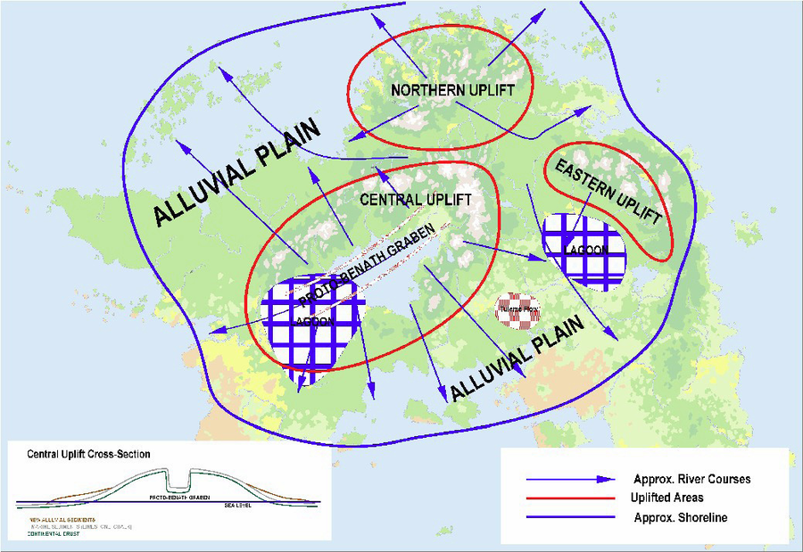
For reasons unknowable, the crust under Hârn began to rise in three large areas. It isn't clear that all three regions rose at the same time, but it is clear that sections of Central Hârn, Eastern Hârn, and Northern Hârn experienced major uplifts and made Hârn into an island. Outside these three areas a lesser amount of uplift brought additional land above sea level, creating an island recognizable as Hârn.
 |
Early in this period, it is clear that portions of what is now Káldôr and Thârdic Republic were large lagoons or coastal flats. Within these areas sea water repeatedly entered and evaporated, leaving substantial salt and gypsum deposits behind. Eventually these flats would be buried and thus preserved to be mined by modern Hârnians.
Benáth Graben
The largest part of the uplift occurred in Central Hârn. Here the uplift was so great that it collapsed at its apex. A section twenty miles wide and two hundred miles long fell like a souffle, creating an enormous graben valley. At this time the valley did not house a lake. Instead it was amply drained by a west-flowing river.
Since this area was also the region where the coral reefs had been thickest, the bottom of this valley – and the tops of the surrounding mountains – were predominately formed of limestone. Today this limestone survives intact only in the karst region of Misyn.
Alluvial Expansion
The uplifted regions were capped mostly by relatively soft carbonaceous deposits – limestone and chalk – which quickly eroded. Somewhat slower to erode were the iron-rich sediments from the earlier epochs. These sediments were carried to the lowlands and shallow waters, forming large alluvial plains ringing the uplifted highlands.
The largest plains radiated from the largest uplifts, and eventually the entire region from the Afarazir Islands to the islands of the Gulf of Chakro was built up into a terrestrial landmass. To the east, however, relatively little land was formed, indicating that the sea was deeper in that direction.
Tuleme Lava Flows
At some time during this early period, a large but thin flow of lava spread across the region around the modern Chelna Gap. The flow was probably created by a swarm of volcanoes that were created by magma penetrating crustal rock cracked and weakened by the uplift. Because of the thin viscosity of the lava, the volcanoes did not grow very high and today are unrecognizable.
The flow, however, had a profound effect on the modern topography of the region. The hard basalt covers a layer of much softer sedimentary rock, which doesn't resist erosion with the same tenacity. As a result, cliffs and canyons are prevalent in the region, as seen in the falls of the Wend and Kald rivers and the numerous islands in the lower Kald that have resisted eroding away. All of these features are formed from the hard basalts.
Second Period
Central Mountain Building
The massive uplifting and the collapse of the central highlands into the Benáth Graben inevitably weakened the crust in the central region. This allowed magmas to penetrate the region. In some places these magmas failed to reach the surface, and cooled slowly under the surface to create masses of granite. In some places the magma reached the surface to create volcanoes.
In this period most of the Felsha and Rayesha peaks become recognizable. The volcanism was strongest in the northeastern region, at the head of the graben, and along the northern edge of the graben. The volcanism was weaker on the southern edge, and weakest along the southwestern quadrant. These areas were less stretched by the original uplift, and the crust was less deformed in that direction.
Besides creating new rock and thus building the region even higher, the presence of the hot magma and the pressure created by the new layer of surface basalt had a profound impact on the older sedimentary layers present in the region. Some of the older stone was metamorphosed – most remarkable is the creation of marble from limestone. Hot water created by the magma and percolating through the permeable sandstone dissolved minerals in the sedimentary rock and concentrated them in areas where the water cooled or escaped. The concentrated 'epithermal' mineral deposits include ores of silver, copper, lead, zinc, and even gold. By far the most important of these deposits is at Kiráz, but lesser deposits are hidden throughout the region.
The volcanoes are long extinct, and most have been eroded well past the point where they are easily identified as such. The resulting geological map is now a confusion combination of surface basalts, granite masses that have been exposed by erosion, old sedimentary rock – mostly sand and limestone, with some seafloor sediments that originated below the limestone layer – and metamorphic rock where where the sedimentary rock came in contact with the igneous.
For much of this time Lake Benáth was a marshy, lake-dotted valley. This environment was conducive to the formation of bog iron, and much of this material was swept down the proto-Thârd River in occasional floods. They are found today in the rich iron deposits of Hikun and the Imrium Downs. These lodes are particularly easy to exploit, as the iron ore is available in easily mined soft sediments.
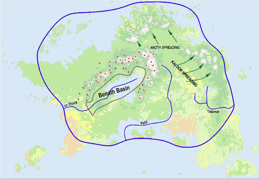
Kald and Anoth Spreading
The reasons for the relative movement of the three main regions of Hârn are obscure – it may be linked to the uplifting process that created the island. But whatever the reason, the regions that are now the Jahl and Sorkin Mountains moved away from the central highlands, stretching the crust between them like taffy. These regions fell to form modern Nuthela and Káldôr.
Early Rivers
In this period the great rivers of Hârn become traceable. The Thârd is the hardest to trace. It certainly did not follow its current route in the upper portions – it probably followed roughly the course of the Pech, judging from the mineral deposits found in that region. The lower portions of the Thârd River changed course frequently over the millenia. At times the mouth of the Thârd was as far north as Shostim, and its possible that it might have wandered as far south as roughly Selvos during this period. In these lower portions, any useful minerals in the sediments would have been dispersed too broadly to be exploitable today.
The Kald followed a course significantly to the west of its current location. At that time, the region that is now the Gulf of Chakro was dry land, and the Kald likely flowed right through it. In its middle reaches – what is now the the Kald Estuary and further upstream, the Kald carved a substantial canyon through the hard basalts of the Tuleme Lava Flows. The Kald still flows through the lower section of this canyon – each of the numerous islands in that section is capped by a block of erosion-resistant basalt. The modern Kald enters that ancient canyon at Tuleme Falls. Those falls have moved many times over the ages, as the channel tends to silt up over time and the swamps above the falls are effectively a delta. The Wend enters the canyon about 10 leagues upstream. Above the Wend the canyon is now filled with sediments.
Southern Káldôr was drained to the east by a river system than can still be traced, though it has changed dramatically. At this time the Anadel Highlands had not yet been uplifted, and the upper Osel drained to the west into what is now the Onden River. At that time the Onden flowed directly to the sea - later it would be diverted south, into the Horka.
The Anoth River was a major watercourse at this time, and the Anoth Delta was already growing well into the eastern sea.
Anrist Hitch
Throughout the geological history of Hârn, the entire continental plate that Hârn rides upon was moving slowly to the east. This motion is created by the spreading of the seafloor between Lythia and Kamerand, and is responsible for many of Lythia's most important mountain ranges. But Hârn itself has generally ridden along peacefully, far from the plate margins where the most violent activity occurs.
However, Hârn has collided into various seamounts and islands, incorporating them into its eastern margins. The most prominent of these collisions built much of the Sorkin Mountains and the rugged terrain between those mountains and the sea. The victim of this bulldozing was a chain of extinct hotspot volcanoes, the oldest of which is Keron Island. Material from these islands is now part of the jumble that is the Eastern Sorkins, and Anrist Point is a basalt remnant of one of these volcanoes.
But the islands did not take easily to this treatment. They pushed back on Hârn, causing the motion of the island to change. A "hitch" in the motion was created, which can be seen in the shape of the Káldôr Depression. The Sorkin Mountains swiveled from their previous north-south orientation, allowing southern Káldôr to stretch more widely than the north.
 |
Third Period
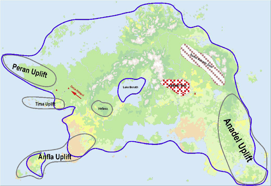
Peripheral Uplifts
In the relatively recent past, a second phase of uplifts occurred around much of the perimeter of Hârn. The cause of this uplift is obscure, but might be attributed to a weakening of the crust due to the stretching and stresses caused by earlier uplifts. This uplift was substantially less dramatic than the earlier mountain-forming epoch, and of a very different nature. Whereas the original uplift process effectively blew Hârn up like a bubble, these later processes were marked by numerous granite intrusions. This later process expanded the island's extent in several directions.
The largest of the five major uplift zones was in southeastern Hârn, and it brought Mèlderýn up from under the sea and built the hills of Anadel. A second major zone was in northwestern Hârn, and created the Obodu Hills of Peran and the Mirath Islands. The third zone was in the southwest, and lifted Anfla Island and much of what is now the Ternu Heath and Cape Gemal. The fourth was an east-west wrinkle that lifted the Tirsa Islands and western Réthem into place. The fifth uplift created the Hefiosa, and is treated in a separate section.
In all of these regions the uplift was driven by granitic intrusions, which both created new bedrock material and also lifted the covering material higher. This older material consisted of weak carbonaceous stone, easily eroded away. Thus in many areas the process was a race between the land-creation process of uplift and the land-destroying process of wave erosion. Where the uplift was the stronger force substantial hills resulted, but elsewhere the uplift was eroded into islands, or even lost entirely under the sea.
In most areas the granitic intrusions remained well below the surface, but in a few areas where it penetrated higher it had important effects. The heat of the intruding magmas metamorphosed neighboring chalk and limestone, creating talc, soapstone, and (rarely) marble. In addition, it also created important tin and copper deposits, and many of Hârn's most important mining regions exploit minerals at the margins of the granitic intrusions.
Sorkin Volcanoes
The incorporation of the Keron Seamount Chain into the Sorkin region had a secondary effect on the region. Some of the seamount material was subducted under the island, creating a pool of magma which emerged in a volcanic zone about a hundred miles inland. This zone stretched from Nuthela to Tontury Lake, built up the western Sorkin Mountains, and created the rugged foothills that separates Kingdom of Ázadmêre from the Kingdom of Káldôr. The magma source is now apparently depleted, but inevitably will be replenished when Keron Island itself is finally bulldozed by the slowly moving island.
Kathela Basalts
The final paroxysm of the volcanism in the central mountains created a large swarm of small, low-lying shield volcanoes in the western Kald Basin. The likely cause was the weakening of the crust in the region due to the spreading activity that created the basin. The result is the Kathela Hills – a large hummocky plateau.
The flows went right over the bed of the Kald River, forcing it to its current location, which closely follows the edge of the flows. This in turn created the Tuleme Marsh and waterfall.
Káldôr Volcanoes
While the Kathela Basalts are by far the most prominent volcanic feature of the region, other smaller volcanoes dot the Kald Basin. These volcanoes are all small – few, in fact, are even recognizable. But they have had an important impact on the region, as many of Káldôr's mines exploit ores concentrated by volcanic or epithermal action. The volcanoes were formed by small magma sources finding weaknesses in the bedrock caused by the valley spreading.
Tontury Lake and the Osel River
It isn't obvious why Tontury Lake should drain in such a roundabout way – bypassing the seemingly easier route through Vemionshire in favor of the hilly Upper Osel. In fact, it required two rivers to reverse course to create this unusual drainage system
The uplift of the Anadel region also affected the topography of the Kald Basin. Before the uplift, the Tontury region was a lowland stretching towards Telumar and drained to the Sea of Ivae. The Upper Osel region also drained into the same river system that ran through Telumar. As the region around Telumar rose, the Osel River reversed course and the valley lost its drainage. Eventually the fork of the Osel River that had formerly drained the Upper Osel region to the east also reversed course, providing the valley with a way to drain to the west instead. Thus the Ilme-Osel river system took its modern form. But the new drainage system is substantially higher than the old drainage system, transforming the formerly well-drained valley into a lake and swamp.
 |
Hefiosa and Lake Benáth
The fifth major uplift in this epoch was comparatively dramatic and compact. The Hefiosa Hills emerged from the bottom of the Benáth Valley to rapidly form a massive plateau. The process was driven by a mass of granitic intrusions, much of which is exposed in the canyons of the region. Today the region consists of a layer of sedimentary rock laying upon a broad igneous base.
As the Hefiosa rose, the Thârd River repeatedly changed course to avoid it, but it inevitably lost the battle to drain the valley. The lakes and marshes of the Benáth Basin slowly merged into a single massive lake. At this time the lake was still significantly smaller than today, as the Felsha Mountains hemmed it in more tightly on the southern edge.
Denia Hotspot
Probably unrelated to the uplifting was the development of a hotspot volcano northwest of Menekai. As Hârn slowly moved southeast, the hotspot stayed anchored to the deeper core and thus slowly moved northwest relative to Hârn's surface. It left behind a trail of basalt and a twenty-plus mile wide valley. The hotspot finally petered out after moving over fifty miles, and created a large, shallow caldera. The later action of water and ice leveled the caldera floor, creating the Denia Marshes. The volcano is now dormant – probably extinct. The marshes surely conceal some of Hârn's most interesting geology, and chances are excellent that a variety of interesting minerals are hidden there.
 |
The valley marking the volcano's trail is a common feature of hotspots. The interior of the path behind a hotspot tends to collapse, leaving twin ridges on each side. But the Denia path is unusual because for much of its length the valley flows towards the terminal caldera. Originally the valley flowed away from the caldera, which is normally the highest point on the path. But the topology apparently changed during the ice age, when the valley was covered by an extension of the Tirpal Ice Sheet. When the ice melted it left a plethora of lakes in the central segment of the valley, which was now its highest point.
About forty miles to the west another volcano erupted, near Bedenes. This volcano is also dormant, and may or may not be related to the hotspot.
The hotspot probably is not related to the Peran Uplift - the Denia Caldera is fairly recent, and if the hotspot is still active it must be fairly nearby. It is more plausible that the hotspot was related to the Hefiosa Uplift, but the evidence is inconclusive.
Ice Ages
Glaciation
The history of glaciation on Hârn is most plainly seen in the fjords of Orbaal. The number of glacial cycles is unknown, but it is plain that during the glacial maxima sea level was substantially lower. The Orbaalese glaciers were thus able to scour valleys deep into what is now underwater. When the sea level rose, these valleys were largely flooded, creating the watery fjords seen today.
Glaciers also deepened valleys in Hârn's other mountain ranges. Perhaps the most prominent glacial feature is Lake Myen, in the foothills of the Felsha Mountains. The lake is dammed by a glacial moraine – the mass of gravel and boulders bulldozed into place by the front edge of the glacier, then left behind as the glacier melted. Direna Lake in the other side of the Felsha Mountains has a similar origin. Lake Arain in the Sorkin Mountains probably existed before the ice age, but it certainly was deepened by glacial action. Most glacial features, however, are comparatively subtle, and it is difficult to determine the full extent of glacial ice.
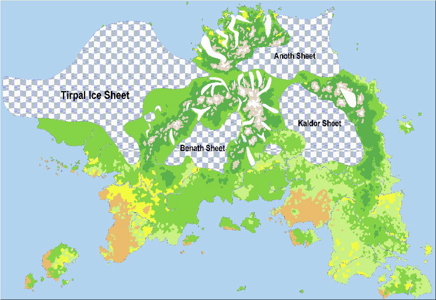
In addition to the glaciers that carved the mountains, at least four major ice sheets were created in the cold, wet climate of the glacial period. The ice sheets formed wherever snow could accumulate faster than it could melt and drain, which was the case in the relatively flat basins and plains. Ice sheets do not move like glaciers, and their effects on the topography can be subtle. However, in three areas they had a profound impact.
Before the glacial period, the Sea of Tirpal was a broad sedimentary plain. The pressure of the ice sheet that built up in this wet region compressed the soil and bedrock to the point that when the ice melted and the sea level returned to normal, most of the region was now submerged. The outer perimeter of the ice sheet was affected less, and the coastal plain survives in the Afarazir Islands. The same phenomenon inundated what is now Jarin Bay and turned Kereva from a peninsula into an island.
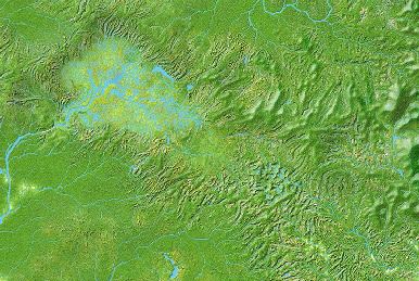
Lake Benáth
Glacial action had a profound effect on Lake Benáth and the hills around its southern margin. Before the glacial epoch Lake Benáth was substantially smaller – constrained on its southern edge by an extension of the Felsha Mountains. These southern mountains were the site of the thickest and most active ice flows on Hârn. The region still receives more precipitation than most of Hârn, and the moderate temperatures in the area made the glaciers more volatile and erosive. As a result the mountains were ground down to a level which, when the ice sheet finally retreated, was below the level of the lake. A few islands and promontories remain above water to hint at the submerged mountain landscape.
 |
As the ice melted, Lake Benáth was reborn as a much larger lake. Lake level was substantially higher than it is today, and its spillways were repeatedly blocked by ice dams. The lake found several different spillways besides the modern Thârd. The most obvious was the Pech-Imris route, but at least one other canyon in the Hefiosa was the drain for a time, and various canyons in Athul were created by the icy lake waters. The ice dams that formed intermittently across the heads of the Thârd and Pech Rivers often broke suddenly, released enormous floods that carved the Thârd Valley and numerous cliffs and canyon in the Hefiosa. These watercourses are marked by gravel deposits, seemingly inexplicable cliffs, dry canyons, and boulder fields. And throughout the entire floodplain of the Thârd as far as its mouth, large boulders as large as wagons are sometimes found – carried there by rafts of ice.
Glacial Features
While the fjords of Orbaal and the deep valleys and moraine lakes of the high mountains are well-known glacial features, there are other places where the ice shaped the landscape. Across the Farin from Mount Putest is a 200 square mile region dotted with hundreds of lakes – the site of a small ice sheet. The Denia Caldera was leveled and transformed into a swampland by a tongue of the Tirpal Sheet. Similar, smaller lake-dotted districts exist in Nuthela, Equeth, and Peran.
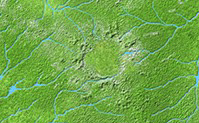
Peran Impact Event
Recently – geologically speaking – Peran was hit by a large meteor which left an impact crater about five miles in diameter. The crater is still plainly evident as an ring of hills surrounding a slightly domed plain.
 |
Part Three: Survey of Mines
- Geology 15
- Geology 16
- Geology 17
It should be noted that many mines produce more than one mineral, and the labels on the map only show the ore of the greatest importance from each site. Not all mines are equal – the most productive are major industrial operations employing a hundred or more miners, while the least are scarcely more than pits visited a few times a year by a local work crew. And mines eventually are exhausted, and we can only guess at the scores of mines that no longer merit inclusion on the maps.
Káldôr
Káldôr has a variety of mines spread broadly across the region. The scattered geography suggests that no mining region is particularly rich, and probably few of Káldôr's mines would be competitive with the mines of other regions were Káldôr less isolated.
The main exception is salt, which is mined in deposits ranging from the edge of the Oselmarch to Meselyneshire to Vemionshire. All of these mines tap the same halite deposit created when Hârn was just emerging from the sea. Wherever geology has conspired to bring the deposit close to the surface the halite is mined.
Tin and copper (and rarely, lead) are found in small quantities in Meselynshire and Vemionshire. The original ores are associated with igneous intrusions, and very low grade ores are common across Káldôr. Only where percolating groundwater has concentrated the minerals by dissolving, moving, and then depositing them again are the ores rich enough to be mined profitably. This "supergene" process has only been active in a handful of locations.
More dramatic are the epithermal deposits associated with volcanism in the Taniran Hills around the Thelshire-Oselshire border. The region is dominated by an enormous shield volcano, and where the magma cooled underground important minerals were concentrated. These minerals were further concentrated by the action of hot water, dissolving and then redepositing the minerals as it percolated on the margins of the igneous activity. The volcano is long extinct, but dotted around a twenty mile radius are ore bodies containing lead, silver, copper, and tin. Several are exploited today, and many more have been played out over Káldôr's long history.
Káldôr's other important mining district is the Lonemor iron mines of northern Balimshire. These mines tap iron deposits created when Hârn was still a shallow sea. Faulting in the region has exposed these deposits along ridges in the hilly area. Similar orebodies are exposed in eastern Thelshire and near Kobing. All of these mines are virtually inexhaustible, but require hard rock breaking to exploit and are poorly located. In metal-poor Káldôr, though, they are of critical importance.
Káldôr's famous salt mines have had an unfortunate impact on the region's metallurgic resources. The vast alkaline deposits have ensured that most of Káldôr's soils are neutral or alkaline. Káldôr has several marshes but few true bogs, and the lack of acidity inhibits bog iron formation. Nowhere in Káldôr is bog iron found in enough quantity to be of more than local interest.
Thârdic Republic
The Thârdic Republic is a mineral powerhouse among Hârnic states. Most famous are the silver deposits of the Hefiosa and Pech Valley. These are alluvial deposits, the original lodes being lost in the Rayesha Mountains. The deposits indicate that the Thârd River once flowed right through what is now the Hefiosa, delivering the valuable sediments.
More important, though, are the numerous iron mines in the Hefiosa, Kom, and Imrium regions. These are rich and easily exploited deposits of bog iron, washed down from prehistoric marshes that once filled much of the Benáth Basin. Their locations show the many routes the Thârd has taken over the epochs. Most of these lodes have been uplifted to their current elevations above the lake, effectively disguising their origins.
When Hârn was first emerging from under the sea, much of Thârdic Republic was a large lagoon or flatland where seawater repeatedly flooded and evaporated. The water left behind enormous salt and gypsum deposits. Most of these deposits have been jumbled, buried, or destroyed, but some have survived and are close enough to the surface to be mined. Salt is mined near Imrium, Dumon, Ostenor, and Peden. Gypsum is mined in earnest near Telen.
A handful of very important lead and zinc deposits are found in limestone formations exposed in the southern Rayesha Mountains and across the Thârd in the Cassinar and Quilver Hills. These deposits form when calcite in the limestone recrystallizes, ejecting impurities that then become concentrated in the neighboring stone. The two minerals are often found together.
Tin deposits were formed by intruding granite – as the granite cools various minerals are concentrated. In the Rayesha Mountains and the Hefiosa this is a common process, and it is also found in the Waroak Hills near Moleryn. It should be noted that most mines do not exploit the primary lode, but instead exploit the placer deposits below them. Copper deposits in these regions were also formed by essentially the same process. The handful of copper deposits outside these two regions were formed when Hârn was on the ocean floor, and are they are exposed today due to uplifting and erosion.
Kandáy
Note: ADDlink to Hârn MINES Kandáy.
- Note: Colour Highlights: Yellow
- Colour LINK Text: Possible Link
Kandáy's mineral resources derive from two main sources. Southern Kandáy – from the Eryn River to Cape Gemal – is dotted with granite masses, mostly still covered. These intrusions created tin, copper, and lead ores that are mined in Torenshire and Erynashire. They also metamorphosed overlying carbonaceous materials, creating the soapstone and marble quarried along the coast.
The other resource that Kandáy has in relative abundance is bog iron. Kandáy's largest source is the ancient bog iron easily dug up near Chison. Near Hebon and Selvos are similar deposits created by now-dried up bogs. These lodes merely scratch the surface of Kandáy's bog iron potential. The same process that created them is constantly working to create more iron ore in the many bogs of western Kandáy.
Réthem
Réthem's mineral riches come from a wide variety of sources. Economically, the most important are the porphyric orebodies found throughout the southern Rayesha mountains. Copper, tin, and lead are plentiful in the region, and silver is often found in the same ores. The proximity of these resources to water transportation make the Gomisen River Valley one of the most important mining regions on Hârn.
The southern reaches of the Rayesha Mountains include salt mines – a surprising feature at this elevation in a humid region. These formations are remnants of an ancient coastal salt flat, uplifted in the early history of the Rayeshas, and later covered by basalts and sediments. Iron in the same area consists of deposits created in the ancient seafloor and also uplifted.
But the overwhelming majority of Réthem's iron comes from bog iron. Bog iron was once available in the floodplain of the Thârd, washed down from the prehistoric bogs of the Benáth Basin, but these sources have been thoroughly depleted. Today prehistoric bog iron is gathered near Menakai, and bogs are directly harvested along the Gomisen River and near Weseda and Arketh.
Western Réthem has a smattering of tin, lead, and copper mines. These were formed in the uplifting process that raised the Tirsa Islands and much of Hohnamshire. Granitic intrusions in the region created the deposits, which are found in a desultory line from Tormau almost to Shostim.
An odd feature of Réthem is a copper deposit east of the Hohnam Marshes. This deposit formed undersea around an ancient vent and was uplifted very early in Hârn's prehistory. The lode also produces lead and zinc, and is easily mined from the chalky substrate.
Réthem has two silver mines, both created by volcanic activity. The mine near Menekai exploits alluvial ores eroded from a nearby small volcano, one of many in the Rayesha Mountains. A similar orebody is exploited near Bedenes. The broad volcano that created it is relatively recent and has no obvious neighbors. It may be related to the nearby uplifts, or it may be a small hotspot. While dormant today, it still has the potential for further activity.
Mèlderýn
Mèlderýn is blessed with some of the most productive mining regions on Hârn. Two major ore-forming processes are apparent in the region. The granitic intrusions that built most of the region created innumerable lodes of tin and copper, mainly in the Anadel Highlands and the Kenmust Downs of Birenshire. And the same uplifting process raised seafloor sediments rich in lead, zinc, and silver, mostly in the Anadels.
The uplifting process created substantial tidal flats that for a time allowed salt and gypsum to accumulate. These deposits were lifted further, preserving them, and are now mined in a zone stretching all along the eastern coast, about ten miles inland.
The handful of iron deposits exploited in Birenshire and Elorinshire are extremely ancient bog iron deposits, mostly predating the creation of the Anadel Highlands. The iron was formed in swamps when the region was still a lowland, then washed into river channels where the ore was concentrated in gravel beds. As the Anadels rose, the bogs and river systems were destroyed, but the iron-rich gravels remained.
The Isle of Mèlderýn is hardly as blessed as the neighboring mainland, but a few tin and copper mines reveal that the same process that built the Anadels also raised the island. A few deposits of prehistoric bog iron are exploited as well, but today there are no recent bogs to exploit. The vast Leonese Marshes are too salty and alkaline for iron formation.
The island's most important minerals are found in its numerous quarries. Undersea carbonaceous deposits were uplifted to create the island, and in many places the original chalk and limestone was metamorphosed by contact with hot magma. The many quarries on the island produce large amounts of lime, which is used in the mortar that makes Cherafir's remarkable architecture possible. They also produce soapstone and marble. Most of the quarries are along the Tuven River, and boats are essential for efficient transportation. Almost every community of any size in Mèlderýn has a quarry to produce the invaluable lime as well as building stone.
Kiráz and Kingdom of Ázadmêre
Kingdom of Ázadmêre is famous for having been practically carved out of solid granite, but it's actually the cracks in the granite that attracts the Khuzdul. The cracks can contain rich veins of gold, with silver, copper and tin mixed in as well. The ores form as hot water dissolves the minerals from nearby sources, then deposits the minerals again as it cools in the cracks. The mines of Kingdom of Ázadmêre (and Kiráz) are a spiderweb of tunnels leading up these veins.
The granite formations that form Kingdom of Ázadmêre and Kiráz proper do not contain any iron, and therefore other mines such as Fana and Ushet were created. The Sorkin Mountains have a particularly chaotic history, and chunks of undersea crust are juxtaposed with pieces of ancient undersea volcanoes and obsidian-bearing lava flows. Kingdom of Ázadmêre is at an important locus of these many elements. Glaciers have scoured away to the cover to reveal the geology to the sharp-eyed Khuzdul, and they have also created easily exploited placer deposits. Almost every mineral-forming process known can be found someplace in the region, acting on a wide variety of sources materials including ancient crust, seafloor sediments, basalts and magmas. The profusion of gemstones and minerals in the region is unmatched anywhere on Kethira.
Only Kiráz is close. In fact, Kiráz trumps Kingdom of Ázadmêre in having ample quantities of high-quality marble available. The marble is not at Kiráz itself, but in the nearby Rayesha Mountains, and the Khuzdul of Kiráz generally had to look farther afield to get the same variety of ores. But the essential structure of the two main mines is the same. Only the proximity to other kinds of formations was different.
For Kiráz, as Kingdom of Ázadmêre, the most difficult ore to obtain was ordinary iron. In both regions the source they discovered was formed in ancient seabed sediments, uplifted in Hârn's most ancient epoch. These hard rock formation are difficult to mine. In Kingdom of Ázadmêre, some placer deposits were created by glaciation, making ore gravels that are easily scooped up. Mostly, though, the mining requires the difficult task of breaking hard rock. It should not be surprising that the Khuzdul expend so much effort to making their iron works truly remarkable – as difficult as the mining is, the metal should not be wasted on items of mediocre quality.
A
- A
- A