Hârn Map Scaling
A complete article on Game Design and the Land size of Hârn.
Colour Text: Code: public class
| 900px |
Contents
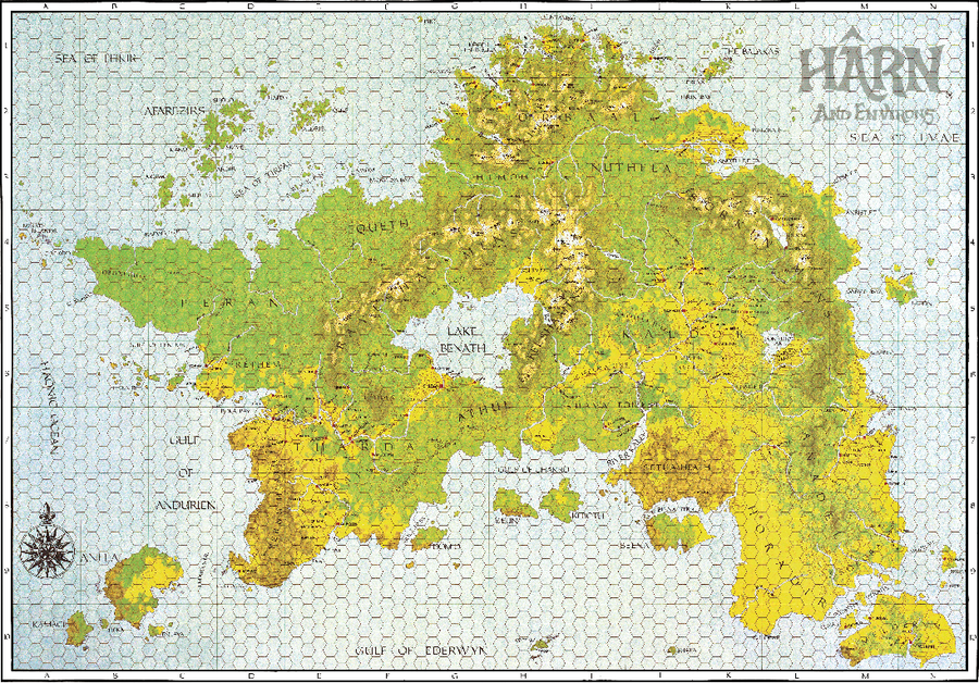
Hârn Regional Map
See: Hârn Regional Map
- 10 down x 14 wide squares (A-N, 1-10) = 24 total
- Each hold hexes: 5 hexes high x 5 hexes wide
- Size per hex = 1 cm = 5 Hârnic Leagues = 20km or 12.5 miles
- Region = (20*20) 400km2
- Each hold hexes: 5 hexes high x 5 hexes wide
- Count up Hexes for Width x Height = Area
- 14 * 100 = 1,400 km wide
- 10 * 100 = 1,000 km high
- 1,400 * 1,000 = 14,000 km2
|
- On this Map
|
Kilometers |
Mile | |
|---|---|---|
| Width | 1,244 km | 773 miles |
| Length | 1,270 km | 790 miles |
| Area Total | 696,241 km2 | 268,581 sq mi |
| % Water | 2.5% | 2.5% |
- Source: Texas
| Regional Hârn Map | |||||||||||||||
|---|---|---|---|---|---|---|---|---|---|---|---|---|---|---|---|
| A | B | C | D | E | F | G | H | I | J | K | L | M | N | ||
| 1 | A1 | B2 | C1 | D1 | E1 | F1 | G1 | H1 | I1 | J1 | K1 | L1 | M1 | N1 | 1 |
| 2 | A2 | B2 | C2 | D2 | E2 | F2 | G2 | H2 | I2 | J2 | K2 | L2 | M2 | N2 | 2 |
| 3 | A3 | B3 | C3 | D3 | E3 | F3 | G3 | H3 | I3 | J3 | K3 | L3 | M3 | N3 | 3 |
| 4 | A4 | B4 | C4 | D4 | E4 | F4 | G4 | H4 | I4 | J4 | K4 | L4 | M4 | N4 | 4 |
| 5 | A5 | B5 | C5 | D5 | E5 | F5 | G5 | H5 | I5 | J5 | K5 | L5 | M5 | N5 | 5 |
| 6 | A6 | B6 | C6 | D6 | E6 | F6 | G6 | H6 | I6 | J6 | K6 | L6 | M6 | N6 | 6 |
| 7 | A7 | B7 | C7 | D7 | E7 | F7 | G7 | H7 | I7 | J7 | K7 | L7 | M7 | N7 | 7 |
| 8 | A8 | B8 | C8 | D8 | E8 | F8 | G8 | H8 | I8 | J8 | K8 | L8 | M8 | N8 | 8 |
| 9 | A9 | B9 | C9 | D9 | E9 | F9 | G9 | H9 | I9 | J9 | K9 | L9 | M9 | N9 | 9 |
| 10 | A10 | B10 | C10 | D10 | E10 | F10 | G10 | H10 | I10 | J10 | K10 | L10 | M10 | N10 | 10 |
| A | B | C | D | E | F | G | H | I | J | K | L | M | N | ||
- Highlight available map squares with: Red overlay, Black Text showing Tile# (ie. C6 CG5000E-C6), and a link to Map Tile Page.
- Make a Regional Map with Cultures as a colour, and also icons for location types (ie. Castle, Keep, Capital, Site, and so on)
- Colours used: A, B, H (1), K (2), L (3)
Hârn_Regional_Interactive_Map_200_Measuring.pdf
- Drive:\OLD System\Spare 2\Old Downloads\[-=Sorting\-=TO SORT\
- According to this map, 25 Leagues = 100km, each making up 14 (+1 extra on left) (A-N) across, 10 up/down (1-X)
Measured
Across: 14 Up/Down: 10 Area: 14 x 10 * 100km = 1400*1000km = 1,400,000 km2 :: ie: 15 km x 15 km = 225km sq
Compared to The Witcher 3
- The slides mention the size of two of the areas included in the game: the city of Novigrad measures 8.5 x 8.5 km for a total size of 72.25 square km, while Skellige is 8 x 8 km, meaning 64 square km. Summed up, the two areas cover 136.25 square km. Original Source with PDFs and discussion


Compared to Kingdoms
- Kingdoms = 16 x 16 = 256 km2
[quote=Cyfieithydd;490123197938006220]
[quote=HansMaulwurf;490123197936854679]how big is the world ?
how many people are working on this game? [/quote]
[quote=Cyfieithydd;490123197938006220] World is 16x16 km There are 3 of us (me, composer and landscapist) but the most of work was done by myself. And of couse if game will be success, i'll try to hire more people to make developing process faster. [/quote]
A
- A
- A
Size of Hârn
Taken from Hârn forum How large is Hârn?
Warden: How big is the Hârn landmass? I ask because, I think it's the same size as the UK, but how can it account for all those different cultures?
DucatiDon: I believe Hârn is slightly smaller than the British Isle.
Peter the skald: Bigger than Britain I think...smaller than Britain and Ireland....'bout the size of France...
Merdain: Someone overlayed the map of Hârn on the map of the United Kingdom. Of course I cannot find it at this immediate moment, but I was surprised by the fact that the UK seemed to be at most only two thirds the size of Hârn. Hopefully someone on the forum can point us to this map comparison. In the meantime I will re-check my materials to find these maps....
pokep: For a totally back-of-the-envelope estimate, Hârn is roughly bounded by the 20W and 40W longitudes, and the 40N and 50N latitudes. That rectangle is approximately 1/18 * 1/18 * .71 of the surface area of the world. (The .71 comes from the fact that the 45 latitude the circumference of the world is 1/sqrt(2) times the circumference at the equator). Earth has a surface area of 510,000,000 km2, so assuming Kethira is roughly the same (IIRC it's a bit smaller), we have the bounding rectangle is about 1,100,000 km2. My eyeball guesses that the actual area is a little more than half that - we'll say 550,000 sq. km, or about 200,000 sq mi.
Britain is about 230,000 sq km. France 674,000 sq km. Ireland 84,000. So about two Britains plus an Ireland.
I'll let someone more ambitious count the hexes to get a more exact value.
The Texas map looks about right. Texas is about 700,000 sq km.
|
Kilometers |
Mile | |
|---|---|---|
| Width | 1,244 km | 773 miles |
| Length | 1,270 km | 790 miles |
| Area Total | 696,241 km2 | 268,581 sq mi |
| % Water | 2.5% | 2.5% |
- Source: Texas
Krazma: I seem to recall one of the old advertisements stating something about Hârn being approximately the same size as Madagascar. I may be mis-remembering that, but glancing at a world map, it seems to be about right.
There's also this, but I don't recall where I found the original.

|
SableFox: For all practical purposes Hârn is about the same size as the British Isles (UK & Eire). The kingdoms are about the same size as the late Celtic or early Saxon ones (though Chybisa isn't even big enough to be a county). You can't rationally account for all the culture - someone just want a mix of their favourite fantasy/historic settings and lumped them all together (and why not? It is fantasy and it has proved to work).
Though the Solari crusades is the obvious 'knights go off and stomp' scenario, the latent Agrik vs Larani armagheddon is the more likely parallel to the crusades IMO.
Ilkka:

Hârn is about twice the combined land mass of the British Isles.
The civilized SW portion of Hârn roughly compares to Ireland.
The distance from Cherafir to Thay very closely equals the distance from London to York.
Sorry about the size of that map.
Nolomar: Here are the other files mentioned earlier.


Nolomar: And the last couple.


A
- A
- A
Images
- A
Image:: No Link
Image:: Size:: No Link
Image:: Size:: No Link
Image:: Size:: No Link
Colour Text
- Blue writing
- Lime Green writing
- Green writing
Colour Text: Code
public class
- Change all code to use wikimedia extension SyntaxHighlight_GeSHi
<syntaxhighlight lang="python">
def quickSort(arr):
 less = []
 pivotList = []
 more = []
 if len(arr) <= 1:
 return arr
 else:
 pass
</syntaxhighlight>
Simple Table with Heading with Coloured Caption
|
Unit Type |
Unit Name |
Unit
Abbreviation |
|---|---|---|
| Tactical Reconnaissance | Heeresluftgruppe | (H) Gr |
| Long Range | Fernaufklärungsgruppe | (F) Gr |
| Coastal Groups | Küstenfliegergruppe | KFGr |
| Long Range Bomber | Kampfgruppe | KGr |
Multi-Grey Rows
| Maritime Aircraft | |
|---|---|
| Code | Description |
| DY xxx | 1 crew, weighing up to 600 Kg |
| DE xxx | 1-3 crew, weighing up to 2200 kg |
| DI xxx | 1-4 crew, weighing up to 5000 kg |
| DA xxx | Multi-engine, weighing over 5000 kg |
Picture Table with Coloured Caption
| File:Do17 model.jpg |
HTML Colour Names
| HTML Colour Names | ||
|---|---|---|
| Colours | HEX Code | |
| White | span style="color:#FFFFFF" | |
| Silver | span style="color:#C0C0C0" | |
| Gray | span style="color:#808080 | |
| Black | span style="color:#000000 | |
| Red | span style="color:#FF0000 | |
| Maroon | span style="color:#800000 | |
| Yellow | span style="color:#FFFF00 | |
| Olive | span style="color:#808000 | |
| Lime | span style="color:#00FF00 | |
| Green | span style="color:#008000 | |
| Aqua | span style="color:#00FFFF | |
| Teal | span style="color:#008080 | |
| Blue | span style="color:#0000FF | |
| Navy | span style="color:#000080 | |
| Fuchsia | span style="color:#FF00FF | |
| Purple | span style="color:#800080 | |
Category Tables
An example of a Category Table using templates and sub-templates.
| File:Miltary Unit Infobox Screenshot.png |
{{Infobox military unit |unit_name=German 7th Panzer Division |image=[[File:7th Panzer Division logo.svg|75px]] |caption= |country={{flagicon|Nazi Germany}} [[Deutsches Reich]] |allegiance= |type=[[Division (military)|Division]] |branch=[[German Army|Heer]] |dates=18 October 1939 – 8 May 1945 |specialization=[[Panzer]] |command_structure= |size= |current_commander= |garrison= |ceremonial_chief= |nickname="Gespensterdivision" |motto= |colors= |march= |mascot= |battles=[[World War II]] |notable_commanders=[[Georg Stumme]]<br/>[[Erwin Rommel]]<br/>[[Hasso von Manteuffel]] |anniversaries= <!-- Insignia --> |identification_symbol=[[File:7th Panzer Division logo.svg|50px]] |identification_symbol_label=1940 |identification_symbol_2=[[File:7th Panzer Division logo 2.svg|50px]] |identification_symbol_2_label=1941–1945 |identification_symbol_3=[[File:7th Panzer Division logo 3.svg|50px]] |identification_symbol_3_label=at Kursk |identification_symbol_4= |identification_symbol_4_label= }}
Notes
- A
- A