Hârn Selvos Scaling
A complete article on the breakdown on Hârn Maps, from Regional down to interior viewpoint. The expand with game tiling system.
This article will cover the layers/levels of scaling down; (Make into a table with what each includes and it's definition)
- Region ~ Hârn
- Kingdom ~ Kanday ~ Atlas Maps D7, D8, D9, E7, E8, E9, F7, F8, F9
- Shire ~ Perishire
- Hundred ~ Dureve
- Local ~ Selvos
- Interior ~ Selvos Castle
- Local ~ Selvos
- Hundred ~ Dureve
- Shire ~ Perishire
- Kingdom ~ Kanday ~ Atlas Maps D7, D8, D9, E7, E8, E9, F7, F8, F9
- Colours used: A, B or B, H (1), K (2), L (3)
Other additions, to expand later, including People & Population, Buildings within Villages & Towns, Manors & Holdings, History of the region
Selvos - Buildings.pdf (Town & it's buildings), Selvos - Dureve Hundred.pdf (Manors and Holdings), Selvos - People.pdf (Population), Selvos - Ezar's War.pdf (History)
- Things TO DO;
- Campaign Cartographer 2;
- FIX Hârn.FCW for everything on it's proper Layer.
- List Mappa Hârnica Layers into a table, define all details at each zoom scale.
- Hârn - Modified.FCW ~ Split into sections and separate each file (ie. A1 through N10). Use the Trim/Trim Inside Entities function.
- Make a new batch of Kingdom Map Template (like Regional Map Template) to better reflect grid properly.
- REGIONAL MAP TEMPLATE: ADD a KINGDOM GRID layer.
- Kingdom Map Template size: 225 high x 230.93875 wide (18 hexes x 21 hexes) Hex size = 12.5 (Grid=2.50000, Snap=0.50000)
- Regional Map Template size: 625 high x 898.49622 wide (? hexes x ? hexes) Hex size = 12.5 (Grid=60.00000, Snap=12.00000)
- Separate HEX/SQUARE GRID into separate layers. ADD a new layer ATLAS GRID with PURPLE colour. As well as a LOCAL GRID to show size of Local Maps as well.
- Create a series of Atlas Template.FCT into required map pages for Atlas Hârnica series for all of Hârn Regional Map from these new Templates.
- Each Atlas Hârnica square will hold two and roughly one half of each.
- A
- Try importing Atlas Hârnica maps into CC2 to show topographical heights.
- Create a series of Atlas Template.FCT into required map pages for Atlas Hârnica series for all of Hârn Regional Map from these new Templates.
- Create Atlas Hârnica maps for ALL Ocean only areas
- A
- A
- A
- A
- A
- A
Note: ADD proper names and cross-internal links.
Note: ADD list of "special" details to add the various details for extras, ie. saltmarshes of Vashel, under Tamsen Forest.
Note: Text Highlight and Background Colour: Kandáy
Note: Green = I Have, Red = Don't Have, Orange = Old Scan, Blue = Misc, Black = ALL Base (Template)
Note: Colour Highlights: Yellow
Colour LINK Text: Possible Link NAME
Note: Hidden comments <!-- TEXT HERE WILL NOT BE DISPLAYED -->
Note: Anchor Points - Section linking WITHIN pages USE [[Help:Section#Section_linking|Section linking]] or To link to a section in the same page you can use [[#section name|displayed text]], and to link to a section in another page [[page name#section name|displayed text]].
Note: Section linking with arbitrary id USE <span id="anchor_name"></span>. Be sure to use a name that is not likely to be duplicated. One way to do this is to incorporate the titles of the higher-level sections, at least in abbreviated form, e.g., Ontario-Natural_features for the "Natural features" subsection of the "Ontario" section of an article about the provinces of Canada. ADD inside Table Caption/Heaer Text
Contents
Hârn Selvos Scaling
This is how this article scales down
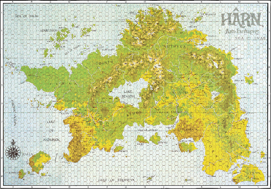
Hârn Regional Map
|
See: Hârn Regional Map
- 1 Hex = 12.5 miles or 20 km
- Local Map is 1,800 (18 cm) x 2,400 (24 cm) feet: 1 cm = 100 feet. 12.5 miles = 66,000 feet
- One 12.5 mile Hex holds 27.5 Local Maps high
- Each Regional Square holds 5 Hexes = 137.5 Local Maps high.
- Regional Map is 10 Regional Squares high = 1375 Local Maps high
- Each Regional Square holds 5 Hexes = 137.5 Local Maps high.
Hârn Regional Map Perishire
Note: ADD Links to Places and Shires
| Regional Hârn Map | |||||||||||||||
|---|---|---|---|---|---|---|---|---|---|---|---|---|---|---|---|
| A | B | C | D | E | F | G | H | I | J | K | L | M | N | ||
| 1 | A1 | B2 | C1 | D1 | E1 | F1 | G1 | H1 | I1 | J1 | K1 | L1 | M1 | N1 | 1 |
| 2 | A2 | B2 | C2 | D2 | E2 | F2 | G2 | H2 | I2 | J2 | K2 | L2 | M2 | N2 | 2 |
| 3 | A3 | B3 | C3 | D3 | E3 | F3 | G3 | H3 | I3 | J3 | K3 | L3 | M3 | N3 | 3 |
| 4 | A4 | B4 | C4 | D4 | E4 | F4 | G4 | H4 | I4 | J4 | K4 | L4 | M4 | N4 | 4 |
| 5 | A5 | B5 | C5 | D5 | E5 | F5 | G5 | H5 | I5 | J5 | K5 | L5 | M5 | N5 | 5 |
| 6 | A6 | B6 | C6 | D6 | E6 | F6 | G6 | H6 | I6 | J6 | K6 | L6 | M6 | N6 | 6 |
| 7 | A7 | B7 | C7 | D7 | E7 | F7 | G7 | H7 | I7 | J7 | K7 | L7 | M7 | N7 | 7 |
| 8 | A8 | B8 | C8 | D8 | E8 | F8 | G8 | H8 | I8 | J8 | K8 | L8 | M8 | N8 | 8 |
| 9 | A9 | B9 | C9 | D9 | E9 | F9 | G9 | H9 | I9 | J9 | K9 | L9 | M9 | N9 | 9 |
| 10 | A10 | B10 | C10 | D10 | E10 | F10 | G10 | H10 | I10 | J10 | K10 | L10 | M10 | N10 | 10 |
| A | B | C | D | E | F | G | H | I | J | K | L | M | N | ||
- NOTE: Change to only include the scaling area for this article
- Perishire covers (D7,E7,D8,E8)
- Colours used: A, B or B, H (1), K (2), L (3)
Perishire
Note: ADD Links to Places and Shires
A shire in the northwest of the Kingdom of Kanday; the shire moot is at Imiden. Ezar’s War added large tracts of land to this shire, a loss the current Rethemi king intends to avenge.
| Hundreds | Hundred Moot | Market Town | Held by1 |
|---|---|---|---|
| Damorane | Waldel | Menekod | Imiden(Waldel), Menekod (Andersa, Antivar, Arcul, Budy, Dinayn, Haval, Luryn, Stedmary, Verad, Waldel, Wenery, Wernu, Yorni), Erone (Corameth) |
| Dureve | Kesethy | Selvos | Selvos (Akonis, Balever, Boba, Elidar, Erkuba, Gebasath, Geffin, Hemhur, Jazo, Minter, Ondravy, Paldur, Ryvila, Sheveth, Terna, Tiney, Trilby, Wintessa), Erone (Erinath) |
| Elos | Forest Hundred | ||
| Helous | Forest Hundred | ||
| Sheda | Sheda | Dunir | Erone (Scinaret), Dunir (Besagarn, Fenak, Leza, Ryce, Waen, Zormel), Imiden(Sheda) |
| Tesien | Forest Hundred | ||
| Timrola | Bydole | Imiden | Erone (Ebona, Tisbur, Varlin), Imiden (Imiden, Bydole, Benalon, Lemago, Nudamar, Pacaen, Tebela, Thex, Urdrane, Wynhur, Zona), Menekod (Gidala, Whycer, Yamal) |
| Urmore | Taskune | Zerien | Imiden (Taskune, Ariune, Dijew, Ganord, Sekir, Wandyn, Yorn), Menekod (Rogg, Tynwym, Utarath), Selvos (Ulben), Zerien (Zerien, Akent, Chaux, Erlane, Dushar, Hortren, Neposen, Rylosin, Sulity, Vemoyan, Wuven) |
| 1 Lands held by feudal lords do not respect shire or even hundred boundaries. The major holding is followed by the particular manor in the shire (in brackets). | |||
- Colours used: A, B or B, H (1), K (2), L (3)
Dureve Hundred
Note: ADD Dureve Hundred article: F:\Dureve Hundred.pdf Note: ADD Links to Places and Shires
| Manor | Hundred | Holder | Acres | Land | HD | Notes |
|---|---|---|---|---|---|---|
| Selvos | Dureve | Chahryn | 1950 | 0.91 | 116 | Castle Town |
| Akonis | Dureve | Tralaer | 2140 | 0.87 | 33 | |
| Balever | Dureve | Marlaen | 1830 | 0.91 | 29 | Fishing Port |
|
Dureve | Bailiff | 1490 | 0.90 | 20 | Forestry |
| Boba | Dureve | Flanzel | 1870 | 0.90 | 30 | |
| Elidar | Dureve | Elida | 1750 | 0.90 | 27 | |
| Erkuba | Dureve | Bailiff | 1650 | 0.91 | 23 | Fishing Port |
| Gebasath | Dureve | Bailiff | 1830 | 0.86 | 25 | |
| Geffin | Dureve | Inkathy | 1820 | 0.90 | 29 | |
| Hemhur | Dureve | Wardotte | 2390 | 0.89 | 35 | |
| Jazo | Dureve | Delreyn | 1850 | 0.89 | 26 | |
| Minter | Dureve | Bailiff | 1790 | 0.91 | 29 | Fishing port |
| Ondravy | Dureve | Arindel | 1940 | 0.88 | 30 | |
| Paldur | Dureve | Bailiff | 1640 | 0.91 | 24 | |
| Ryvila | Dureve | Narquen | 2020 | 0.88 | 31 | |
| Sheveth | Dureve | Spondyner | 1820 | 0.90 | 27 | |
|
Dureve | Bailiff | 1530 | 0.90 | 25 | |
| Terna | Dureve | Lazcaver | 1930 | 0.90 | 31 | |
|
Dureve | Bailiff | 1640 | 0.90 | 24 | |
| Tiney | Dureve | Ulander | 1780 | 0.90 | 25 | |
| Trilby | Dureve | Porisand | 1930 | 0.89 | 30 | Limestone Quarry |
| Wintessa | Dureve | Grallin | 1740 | 0.87 | 26 | |
|
Dureve | Bailiff | 1460 | 0.87 | 21 | Iron Mines |
| Erinath | Dureve | Reblena1 | 2950 | 0.88 | 43 | Chapterhouse |
| Grelda | Dureve | Reblena1 | 3210 | 0.89 | 46 | Chapterhouse |
| Kesethy | Dureve | B/H2 | 2330 | 0.89 | 39 | Hundred Moot |
| Note 1: The Order of the Checkered Shield holds two manors in the Hundred. They belong to the Bishop of Perinore, Rekela Sir Tamys Bakyth, who has his seat in Erone. A knight who served under Sir Grolis during Ezar's War, he has ordered his Reblena to heed the Earl on all manners of defence of the Hundred. Spiritually, the manors report to the senior regional cleric, the Serolan of Selvos. | ||||||
| Note 2: The Sheriff of Peris, Prince Anaflas Milaka (younger brother of the King) holds the manor of Kesethy, the Hundred Moot for Dureve. Located 20 leagues away at Imiden Keep, he has little involvement in the running of the Hundred. Provided the taxes are delivered on time and he receives no major complaints, he is content to leave well enough alone. | ||||||
| Land = Land Quality | ||||||
| HH = Households | ||||||
- Colours used: A, B or B, H (1), K (2), L (3)
a
- Colours to be used: A, B or B, H (1), K (2), L (3) for Layer & Type
- This to be made into Table (Rows=27,Columns=7)
- Includes Manor, Hundred, Holder, Acres, (LQ) Land Quality, (HD) Households, Special Notes
Selvos
Note: ADD Article for Selvos & other Links
- Selvos
- Town and local area
Hârn Regional Map: 1 Hex = 12.5 miles or 20 km
Local Map is 1,800 (18 cm) x 2,400 (24 cm) feet: 1 cm = 100 feet. 12.5 miles = 66,000 feet
Caer Selvos
Note: ADD Article for Selvos Castle & other Links
- Caer Selvos
Notes
- A
- A