Difference between revisions of "Hârn Map Scaling"
m |
m (→Hârn Paper Scaling) |
||
| (6 intermediate revisions by the same user not shown) | |||
| Line 2: | Line 2: | ||
| − | ==[[ | + | == [[Hârn_Map_Scaling|Hârn Paper Scaling]] == |
| + | * A | ||
| + | ** A | ||
| + | |||
| + | == [[Hârn_Paper_Scale_Measurements|Hârn Paper Scale]] == | ||
* '''Area:''' 15 km x 15 km = 225km sq | * '''Area:''' 15 km x 15 km = 225km sq | ||
* A Hârnic League is 2.5 miles or 4 km | * A Hârnic League is 2.5 miles or 4 km | ||
** A | ** A | ||
| − | ==Map Scale== | + | |
| − | ===HârnWorld Mapping Scales=== | + | == Map Scale == |
| + | === HârnWorld Mapping Scales === | ||
* '''Poetic Maps:''' Rarely drawn to an proper scale; often quite fanciful. | * '''Poetic Maps:''' Rarely drawn to an proper scale; often quite fanciful. | ||
** '''Regional Map:''' 1 cm = 12.5 Miles = 20 km = 5 Hârnic Leagues = 1 Hex ~ 300 x 225 Miles (480 x 360 km) | ** '''Regional Map:''' 1 cm = 12.5 Miles = 20 km = 5 Hârnic Leagues = 1 Hex ~ 300 x 225 Miles (480 x 360 km) | ||
| Line 18: | Line 23: | ||
| − | ==Map Types used by Hârn== | + | === Manor Scale === |
| + | For all you map lovers I present: THE MANOR-SCALE MAP!!!!! | ||
| + | |||
| + | * Atlas Hârnica hexes are 5 leagues/12.5 miles/20km in height: 86,605.75 acres. | ||
| + | ** This is an ATLAS-SCALE HEX. | ||
| + | |||
| + | * A 1/5-scale hex is 1 league/2.5 miles/ 4km in height: 3464 acres. | ||
| + | ** This is a MANOR-SCALE HEX. (I have mapped Caleme Abbey at this scale.) | ||
| + | |||
| + | * A 1/25-scale hex is 0.2 leagues/0.5 mile/0.8km in height: 138.57 acres. | ||
| + | ** This is a LOCAL-SCALE HEX. | ||
| + | |||
| + | For reference, the Cities of Harn localmap of Tashal? ~100 acres | ||
| + | the Tashal module localmap of Tashal? ~90 acres | ||
| + | |||
| + | There are 25 LocalHexes in a ManorHex, 25 ManorHexes in an AtlasHex. | ||
| + | So 625 LocalHexes per AtlasHex. 138.57 acres times 625 = 86,606 acres. | ||
| + | |||
| + | (So a LocalHex is roughly equivalent to an Atlas Harnica local map.) | ||
| + | |||
| + | * from [http://www.lythia.com/forum/viewtopic.php?p=173621&sid=65efcba30d20e267a0cb3f2111f6f5f5#p173621 Caleme Abbey: Fanon Help (Links added!)] ~ Manor Scale Map | ||
| + | |||
| + | === Manor Templates === | ||
| + | * 4 Pages per PDF (Manor templates (A4) B&W.pdf & Manor templates (A4) GS.pdf) | ||
| + | ** Five Legue Hex | ||
| + | ** One League Hex | ||
| + | ** Half Mile Hex | ||
| + | ** Tenth Mile Hex (Local Scale) | ||
| + | |||
| + | * from [http://www.lythia.com/game_aides/manor-templates/ Manor Templates] ~ May 8, 2013 by Richard Woollacott | ||
| + | ** Page templates with hex grids at different scales in both A4 and Letter formats and in Black and White and greyscale. Layer information has been included so you can turn off anything you don’t want. | ||
| + | |||
| + | |||
| + | == Map Types used by Hârn == | ||
The toolkit may be used to assist in the drawing of color regional maps, atlas maps, and local maps, as well as black and white interior maps in a style similar to that used for the Hârn roleplaying world. | The toolkit may be used to assist in the drawing of color regional maps, atlas maps, and local maps, as well as black and white interior maps in a style similar to that used for the Hârn roleplaying world. | ||
| Line 29: | Line 67: | ||
| − | ==[[Hârn_Maps#Hârn Regional Map|Hârn Regional Map]]== | + | == [[Hârn_Maps#Hârn Regional Map|Hârn Regional Map]] == |
'''See:''' [[Hârn_Maps#Hârn Regional Map|Hârn Regional Map]] | '''See:''' [[Hârn_Maps#Hârn Regional Map|Hârn Regional Map]] | ||
| Line 296: | Line 334: | ||
| − | ==Selvos Scaling== | + | == [[Measurements_Hârn_Selvos_Scaling|Hârn Selvos Scaling]] == |
* Hârn Regional | * Hârn Regional | ||
** Perishire (D7,E7,D8,E8) | ** Perishire (D7,E7,D8,E8) | ||
| Line 304: | Line 342: | ||
| − | ==A== | + | == A == |
* A | * A | ||
** A | ** A | ||
| Line 321: | Line 359: | ||
| − | ==Images== | + | == Images == |
* A | * A | ||
| − | ===Image:: No Link=== | + | === Image:: No Link === |
[[File:pic.png|link= ]] | [[File:pic.png|link= ]] | ||
| − | ===Image:: Size:: No Link=== | + | === Image:: Size:: No Link === |
[[File:pic.png|900px|link= ]] | [[File:pic.png|900px|link= ]] | ||
| − | ===Image:: Size:: No Link=== | + | === Image:: Size:: No Link === |
[[File:pic.png|900px|link= ]] | [[File:pic.png|900px|link= ]] | ||
| − | ===Image:: Size:: No Link=== | + | === Image:: Size:: No Link === |
[[File:pic.png|900px|link= ]] | [[File:pic.png|900px|link= ]] | ||
| − | ==Colour Text== | + | == Colour Text == |
* <span style="color:#0000FF">Blue writing</span> | * <span style="color:#0000FF">Blue writing</span> | ||
* <span style="color:#00FF00">Lime Green writing</span> | * <span style="color:#00FF00">Lime Green writing</span> | ||
| Line 339: | Line 377: | ||
| − | ===Colour Text: Code=== | + | === Colour Text: Code === |
'''<span style="color:#006699">public class</span>''' | '''<span style="color:#006699">public class</span>''' | ||
* Change all '''<span style="color:#006699">code</span>''' to use wikimedia extension [https://www.mediawiki.org/wiki/Extension:SyntaxHighlight_GeSHi SyntaxHighlight_GeSHi] | * Change all '''<span style="color:#006699">code</span>''' to use wikimedia extension [https://www.mediawiki.org/wiki/Extension:SyntaxHighlight_GeSHi SyntaxHighlight_GeSHi] | ||
| Line 356: | Line 394: | ||
| − | ===Simple Table with Heading with Coloured Caption=== | + | === Simple Table with Heading with Coloured Caption === |
<center> | <center> | ||
{| class="wikitable" | {| class="wikitable" | ||
| Line 388: | Line 426: | ||
| − | ===Multi-Grey Rows=== | + | === Multi-Grey Rows === |
<center> | <center> | ||
{| class="wikitable" width="25%" | {| class="wikitable" width="25%" | ||
| Line 411: | Line 449: | ||
| − | ===Picture Table with Coloured Caption=== | + | === Picture Table with Coloured Caption === |
<center> | <center> | ||
{| | {| | ||
| Line 420: | Line 458: | ||
| − | ===HTML Colour Names=== | + | === HTML Colour Names === |
<center> | <center> | ||
{| class="wikitable" width="25%" | {| class="wikitable" width="25%" | ||
| Line 495: | Line 533: | ||
| − | ===Category Tables=== | + | === Category Tables === |
An example of a Category Table using templates and sub-templates. | An example of a Category Table using templates and sub-templates. | ||
| Line 544: | Line 582: | ||
| − | ==Notes== | + | == Notes == |
* A | * A | ||
** A | ** A | ||
| − | + | [[Category:Measurements]] [[Category:Hârn]] [[Category:Land Size]] | |
Latest revision as of 01:41, 21 August 2017
A complete article on Hârn Maps and the various sizes and scaling down.
Contents
Hârn Paper Scaling
- A
- A
Hârn Paper Scale
- Area: 15 km x 15 km = 225km sq
- A Hârnic League is 2.5 miles or 4 km
- A
Map Scale
HârnWorld Mapping Scales
- Poetic Maps: Rarely drawn to an proper scale; often quite fanciful.
- Regional Map: 1 cm = 12.5 Miles = 20 km = 5 Hârnic Leagues = 1 Hex ~ 300 x 225 Miles (480 x 360 km)
- Atlas Maps: Scale varies according to the area covered. ~ 15 x 10 Leagues (5 Leagues = 8cm)
- Local Maps: 1 mm = 10 feet ~ 2400 feet x 1800 Feet (200 feet = 2cm)
- Interior Maps: 1 mm = 1 foot
- Local Maps: 1 mm = 10 feet ~ 2400 feet x 1800 Feet (200 feet = 2cm)
- Atlas Maps: Scale varies according to the area covered. ~ 15 x 10 Leagues (5 Leagues = 8cm)
- Regional Map: 1 cm = 12.5 Miles = 20 km = 5 Hârnic Leagues = 1 Hex ~ 300 x 225 Miles (480 x 360 km)
Note: Have an example on same "Pic". Template: 24cm x 18cm (A4). 1 League = 2.5 Miles
Manor Scale
For all you map lovers I present: THE MANOR-SCALE MAP!!!!!
- Atlas Hârnica hexes are 5 leagues/12.5 miles/20km in height: 86,605.75 acres.
- This is an ATLAS-SCALE HEX.
- A 1/5-scale hex is 1 league/2.5 miles/ 4km in height: 3464 acres.
- This is a MANOR-SCALE HEX. (I have mapped Caleme Abbey at this scale.)
- A 1/25-scale hex is 0.2 leagues/0.5 mile/0.8km in height: 138.57 acres.
- This is a LOCAL-SCALE HEX.
For reference, the Cities of Harn localmap of Tashal? ~100 acres the Tashal module localmap of Tashal? ~90 acres
There are 25 LocalHexes in a ManorHex, 25 ManorHexes in an AtlasHex. So 625 LocalHexes per AtlasHex. 138.57 acres times 625 = 86,606 acres.
(So a LocalHex is roughly equivalent to an Atlas Harnica local map.)
- from Caleme Abbey: Fanon Help (Links added!) ~ Manor Scale Map
Manor Templates
- 4 Pages per PDF (Manor templates (A4) B&W.pdf & Manor templates (A4) GS.pdf)
- Five Legue Hex
- One League Hex
- Half Mile Hex
- Tenth Mile Hex (Local Scale)
- from Manor Templates ~ May 8, 2013 by Richard Woollacott
- Page templates with hex grids at different scales in both A4 and Letter formats and in Black and White and greyscale. Layer information has been included so you can turn off anything you don’t want.
Map Types used by Hârn
The toolkit may be used to assist in the drawing of color regional maps, atlas maps, and local maps, as well as black and white interior maps in a style similar to that used for the Hârn roleplaying world.
- Regional Maps: (1 cm = 12.5 miles = 12.5 miles = 20 km = 5 Hârnic Leagues = 1 hex)
- Atlas Maps: (8 cm = 12.5 miles)
- Local Maps: (1 mm = 10 feet)
- Interior Maps: (1 mm = 1 foot)
- Local Maps: (1 mm = 10 feet)
- Atlas Maps: (8 cm = 12.5 miles)
NOTE: Make this into a table: Matrix of all measurements & number amounts.
Hârn Regional Map
See: Hârn Regional Map
- 10 down x 14 wide squares (A-N, 1-10) = 24 total
- Each hold hexes: 5 hexes high x 5 hexes wide
- Size per hex = 1 cm = 5 Hârnic Leagues = 20km or 12.5 miles
- Region = (20*20) 400km2
- Each hold hexes: 5 hexes high x 5 hexes wide
- Count up Hexes for Width x Height = Area
- 14 * 100 = 1,400 km wide
- 10 * 100 = 1,000 km high
- 1,400 * 1,000 = 14,000 km2
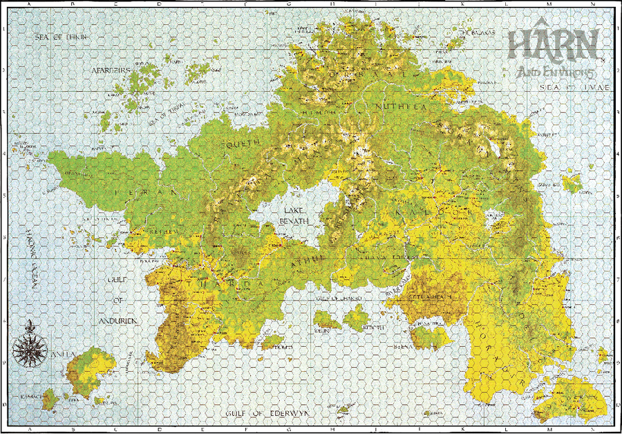
|
- On this Map
|
Kilometers |
Mile | |
|---|---|---|
| Width | 1,244 km | 773 miles |
| Length | 1,270 km | 790 miles |
| Area Total | 696,241 km2 | 268,581 sq mi |
| % Water | 2.5% | 2.5% |
- Source: Texas
| Regional Hârn Map | |||||||||||||||
|---|---|---|---|---|---|---|---|---|---|---|---|---|---|---|---|
| A | B | C | D | E | F | G | H | I | J | K | L | M | N | ||
| 1 | A1 | B2 | C1 | D1 | E1 | F1 | G1 | H1 | I1 | J1 | K1 | L1 | M1 | N1 | 1 |
| 2 | A2 | B2 | C2 | D2 | E2 | F2 | G2 | H2 | I2 | J2 | K2 | L2 | M2 | N2 | 2 |
| 3 | A3 | B3 | C3 | D3 | E3 | F3 | G3 | H3 | I3 | J3 | K3 | L3 | M3 | N3 | 3 |
| 4 | A4 | B4 | C4 | D4 | E4 | F4 | G4 | H4 | I4 | J4 | K4 | L4 | M4 | N4 | 4 |
| 5 | A5 | B5 | C5 | D5 | E5 | F5 | G5 | H5 | I5 | J5 | K5 | L5 | M5 | N5 | 5 |
| 6 | A6 | B6 | C6 | D6 | E6 | F6 | G6 | H6 | I6 | J6 | K6 | L6 | M6 | N6 | 6 |
| 7 | A7 | B7 | C7 | D7 | E7 | F7 | G7 | H7 | I7 | J7 | K7 | L7 | M7 | N7 | 7 |
| 8 | A8 | B8 | C8 | D8 | E8 | F8 | G8 | H8 | I8 | J8 | K8 | L8 | M8 | N8 | 8 |
| 9 | A9 | B9 | C9 | D9 | E9 | F9 | G9 | H9 | I9 | J9 | K9 | L9 | M9 | N9 | 9 |
| 10 | A10 | B10 | C10 | D10 | E10 | F10 | G10 | H10 | I10 | J10 | K10 | L10 | M10 | N10 | 10 |
| A | B | C | D | E | F | G | H | I | J | K | L | M | N | ||
- Highlight available map squares with: Red overlay, Black Text showing Tile# (ie. C6 CG5000E-C6), and a link to Map Tile Page.
- Make a Regional Map with Cultures as a colour, and also icons for location types (ie. Castle, Keep, Capital, Site, and so on)
- Colours used: A, B, H (1), K (2), L (3)
Hârn Selvos Scaling
- Hârn Regional
- Perishire (D7,E7,D8,E8)
- Dureve Hundred
- Selvos
- Caer Selvos
- Selvos
- Dureve Hundred
- Perishire (D7,E7,D8,E8)
A
- A
- A
Colour Text: Code: public class
| File:Do17 model.jpg |
Images
- A
Image:: No Link
Image:: Size:: No Link
Image:: Size:: No Link
Image:: Size:: No Link
Colour Text
- Blue writing
- Lime Green writing
- Green writing
Colour Text: Code
public class
- Change all code to use wikimedia extension SyntaxHighlight_GeSHi
<syntaxhighlight lang="python">
def quickSort(arr):
 less = []
 pivotList = []
 more = []
 if len(arr) <= 1:
 return arr
 else:
 pass
</syntaxhighlight>
Simple Table with Heading with Coloured Caption
|
Unit Type |
Unit Name |
Unit
Abbreviation |
|---|---|---|
| Tactical Reconnaissance | Heeresluftgruppe | (H) Gr |
| Long Range | Fernaufklärungsgruppe | (F) Gr |
| Coastal Groups | Küstenfliegergruppe | KFGr |
| Long Range Bomber | Kampfgruppe | KGr |
Multi-Grey Rows
| Maritime Aircraft | |
|---|---|
| Code | Description |
| DY xxx | 1 crew, weighing up to 600 Kg |
| DE xxx | 1-3 crew, weighing up to 2200 kg |
| DI xxx | 1-4 crew, weighing up to 5000 kg |
| DA xxx | Multi-engine, weighing over 5000 kg |
Picture Table with Coloured Caption
| File:Do17 model.jpg |
HTML Colour Names
| HTML Colour Names | ||
|---|---|---|
| Colours | HEX Code | |
| White | span style="color:#FFFFFF" | |
| Silver | span style="color:#C0C0C0" | |
| Gray | span style="color:#808080 | |
| Black | span style="color:#000000 | |
| Red | span style="color:#FF0000 | |
| Maroon | span style="color:#800000 | |
| Yellow | span style="color:#FFFF00 | |
| Olive | span style="color:#808000 | |
| Lime | span style="color:#00FF00 | |
| Green | span style="color:#008000 | |
| Aqua | span style="color:#00FFFF | |
| Teal | span style="color:#008080 | |
| Blue | span style="color:#0000FF | |
| Navy | span style="color:#000080 | |
| Fuchsia | span style="color:#FF00FF | |
| Purple | span style="color:#800080 | |
Category Tables
An example of a Category Table using templates and sub-templates.
| File:Miltary Unit Infobox Screenshot.png |
{{Infobox military unit |unit_name=German 7th Panzer Division |image=[[File:7th Panzer Division logo.svg|75px]] |caption= |country={{flagicon|Nazi Germany}} [[Deutsches Reich]] |allegiance= |type=[[Division (military)|Division]] |branch=[[German Army|Heer]] |dates=18 October 1939 – 8 May 1945 |specialization=[[Panzer]] |command_structure= |size= |current_commander= |garrison= |ceremonial_chief= |nickname="Gespensterdivision" |motto= |colors= |march= |mascot= |battles=[[World War II]] |notable_commanders=[[Georg Stumme]]<br/>[[Erwin Rommel]]<br/>[[Hasso von Manteuffel]] |anniversaries= <!-- Insignia --> |identification_symbol=[[File:7th Panzer Division logo.svg|50px]] |identification_symbol_label=1940 |identification_symbol_2=[[File:7th Panzer Division logo 2.svg|50px]] |identification_symbol_2_label=1941–1945 |identification_symbol_3=[[File:7th Panzer Division logo 3.svg|50px]] |identification_symbol_3_label=at Kursk |identification_symbol_4= |identification_symbol_4_label= }}
Notes
- A
- A